National NRM update for August 2021. This update represents just a handful among the hundreds of NRM projects going on across Australia, which are made possible through funding from the Australian Government’s National Landcare Program and from respective State governments.
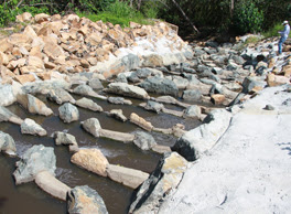 Fishway construction in Mackay-Whitsunday has shown some great outcomes for increasing fish populations in the region, and a next-level fish barrier project being carried out by Reef Catchments and Catchment Solutions will now investigate fish barriers in off stream coastal wetlands and update the stream barriers prioritisation report throughout the region. Read more about the project here.
The extension project is funded by the Australian Government Department of Agriculture, Water and the Environment Reef Trust and delivered through the National Landcare Program Regional Land Partnerships agreement.
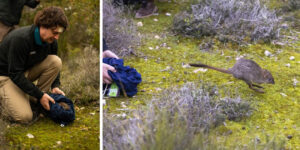 One of Australia’s rarest marsupials, the brush-tailed bettong, has been reintroduced to mainland South Australia after being locally extinct for more than a century.
Forty of the nationally endangered animals have been released at two sites in Dhilba Guuranda-Innes National Park on Yorke Peninsula in a milestone moment for Marna Banggara, an ambitious project to restore lost species to the landscape. The project is jointly funded through the Australian Government’s National Landcare Program, the Northern and Yorke Landscape Board, the South Australian Department for Environment and Water, WWF-Australia and Foundation for National Parks & Wildlife, in partnership with the Narungga Nation Aboriginal Corporation and with the support of Traditional Custodians, the Narungga people.
The 28 females and 12 males were translocated from nearby Wedge Island, where an abundant population of more than 1,500 brush-tailed bettongs live. Health checks showed that many of the females were also carrying pouch young.
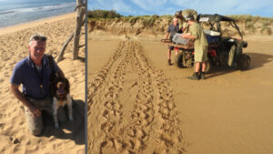 High intensity bushfires around Deepwater National Park, south of Agnes Waters in Queensland last year, have this year created an inviting environment for red foxes and other introduced predators such as feral cats and wild dogs. Port Curtis Coral Coast country includes beaches and islands that are some of the most important marine turtle nesting sites in Queensland, supporting significant breeding populations of the endangered loggerhead turtle, and the vulnerable flatback and green turtle.
Southern Queensland Landscapes have been working with the Gidarjil Bundaberg Land and Sea Rangers, helping identify, map and control pests in the Port Curtis Coral Coast Native Title region, and combining traditional knowledge, practices and lore with western science. Southern Queensland Landscapes have supported training the Sea Rangers to undertake innovative and strategic control activities, including the use of a conservation detector dog, fox den mapping, fumigation and the implementation of other control methods.
For more information on this partnership, visit https://www.sqlandscapes.org.au/partnership-combines-traditional-practices-modern-science-to-save-endangered-turtles
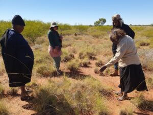 Staff from the NT's Territory NRM recently joined a bilby survey in the northern Tanami region. TNRM also supported a PhD researcher from Charles Darwin University, who worked with Rangers and Traditional Owners (TOs) from the North and South Tanami Indigenous Protected Areas to complete aerial transects, 2ha track plots, scat collection surveys, and record signs of feral cats and feral herbivores. The team flew 455 km of helicopter transects (covering over 4,550 hectares), spent several days walking 22 x 2ha plots and found lots of bilby burrows, diggings, tracks and goona (scat). They collected 112 goona samples across an area of approximately 296,000 hectares, which will be analysed in the lab to extract the DNA to identify how many individual bilbies the goona comes from. While they were there, some of the grassy country was burnt by the TOs to reduce the risk of bigger wildfires later in the season.
This project is supported through funding from the Australian Government’s National Landcare Program.
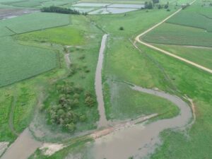 In far north Queensland, Tully Sugar Limited have set aside eight hectares of land to help trial ways of reducing nutrient and sediment run-off as part of a major reef water quality project. Since its construction in 2019, the wetland has been monitored for its effectiveness at removing nutrients and sediment from the water passing through. Data shows it is a high performing site. As wetland vegetation has become more established, the wetland’s nitrogen removal capacity has consistently improved since construction. It is now estimated to remove over 1000 kg of nitrogen per year. Read more about the project here.
Terrain NRM's Wet Tropics Major Integrated Project (MIP) is an innovative and ambitious project that is trialling a whole new approach reef water quality projects to accelerate progress towards the Reef 2050 targets. It is funded by the Queensland Government’s Reef Water Quality Program.
Greater Sydney Local Land Services has released the second series in its ‘Big Shift for Small Farms’ podcast series, which has proved popular with local producers, industry and the community. It is currently ranked number 4 in the Australian charts for a natural podcast and has attracted great interest and feedback among listeners. The Big Shift is all about sharing and growing knowledge amongst all farmers with a focus on sustainable and regenerative land management practices and the new series covers a range of topics including building a farm brand, planning for emergencies, pasture and livestock flood recovery and weed management.
Click here to subscribe to the Big Shift podcast.
This series has been produced by the Grow Love Project with support from Greater Sydney Local Land Services, through funding from the Australian Government's National Landcare Program.
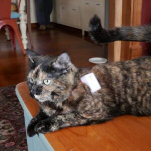 Tasmania's Cradle Coast Authority have released the results of their pilot 'Cradle Coast Cat Tracker Project', providing an important insight into the home ranges of cats living in peri-urban areas. As part of the study, 11 domestic cats were fitted with GPS trackers and monitored for 7 days. Home range size varied from 0.2 to 7 hectares, with a median size of 1.4 hectares. The results show that cats in the Cradle Coast region regularly roam away from their owner’s property visiting numerous neighbours and crossing approximately 3 roads a day. The aim of the study was to provide cat owners with information on how far the average cat roams and what potential dangers they may encounter, helping them make informed decisions about their cat’s safety and care. Click here for more information.
This research is a partnership between Cradle Coast Authority and the Department of Primary Industries, Parks, Water and Environment.
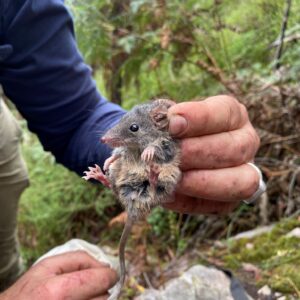 Staff from Wimmera CMA were recently out in the field trapping in the Victoria Range of the Grampians as part of a project to continue the long-term monitoring of the endangered Smoky Mouse (Psuedomys fumeus). Captured individuals were weighed, sexed, microchipped and DNA sampled. Scat samples were also collected to investigate their diet. This information will help monitor their habitat range and several cameras have been set up to capture and monitor their movements.
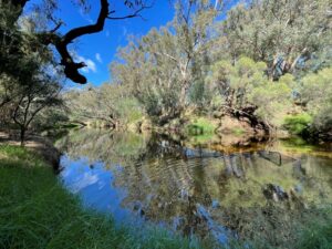 The Peel Harvey Catchment Council has recently teamed up with scientists from Murdoch University to conduct river health assessments across sections of the Murray River in Western Australia. These assessments will provide a snapshot of the current ecological condition of the river against which they can measure the success of future restoration activities in increasing the health and biodiversity of the river and its surrounds. The team carried out assessments at three sites in the middle to upper reaches of the Murray River in autumn 2021, at a time of year when freshwater in-flows to the river are usually low. The results revealed that even the most upstream sites were saline but well oxygenated, providing relatively good water quality to support abundances of native fish.
Glass shrimp displayed signs of a healthy population and smooth marron and gilgie were also present but in low abundances. The exotic species of eastern gambusia was also identified across the three sites, in encouragingly low numbers. The sites will be sampled again this spring when in-flows are usually at their highest to allow an assessment of seasonal changes in aquatic communities. For more information, visit https://peel-harvey.org.au/how-healthy-is-the-murray-river/
The project is supported by the Peel-Harvey Catchment Council through funding from the State Governments Royalties for Regions and the Alcoa Foundation’s Three Rivers One Estuary Initiative.
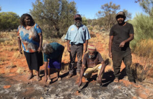 Through ongoing and innovative management methods, the Oak Valley Rangers in South Australia are successfully reducing the spread of Buffel grass in the Maralinga Tjarutja Lands. In addition to applying a range of management techniques, they also monitor treated areas to determine the best ways to avoid herbicide resistance. This is significant research and the results will inform the rangers about the effectiveness of the treatments in specific areas over time. The team are trialling various methods including very hot and extended burns to kill mature plants and seeds and quick cool burns to reduce old biomass and encourage new growth that can then be sprayed with chemical.
This work is funded by the Alinytjara Wilurara Landscape Board with funds from the Australian Government’s National Landcare Program and the 10 Deserts Project as well as through the National Indigenous Australians Agency’s Indigenous Advancement Strategy funding.
